|
The Palestinian Authority makes no attempt to educate its people towards peace and coexistence with Israel. On the contrary, from every possible platform it repeatedly rejects Israel's right to exist, presents the conflict as a religious battle for Islam, depicts the establishment of Israel as an act of imperialism, and perpetuates a picture of the Middle East, both verbally and visually, in which Israel does not exist at all. Israel's destruction is said to be both inevitable and a Palestinian obligation.
The following description of Israel's founding in a Palestinian schoolbook represents the dominant dogma about Israel:
 "Palestine’s war ended with a catastrophe that is unprecedented in history, when the Zionist gangs stole Palestine … and established the so-called State of Israel."
[Arabic Language, Analysis, Literature and Criticism, grade 12, p. 104]
"Palestine’s war ended with a catastrophe that is unprecedented in history, when the Zionist gangs stole Palestine … and established the so-called State of Israel."
[Arabic Language, Analysis, Literature and Criticism, grade 12, p. 104]
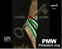
This official PA map of "Palestine” was broadcast on PA TV in September 2011. The map includes both the PA areas and all of Israel (excluding the Golan Heights) wrapped in the Palestinian flag - a symbol of Palestinian sovereignty over the whole area - and has a key through it, symbolizing ownership. Similar maps presenting all of Israel as "Palestine" appear in Palestinian schoolbooks and are shown regularly on PA TV.
|
|
| "Palestine" replaces Israel |
The Palestinian Authority paints a picture - both verbally and visually - of a world in which Israel does not exist. Children’s educational TV teaches that Palestine currently is a "state" (Arabic "dawla" = state) covering 27,000 sq. km - i.e., an area that includes all of Israel (the entire West Bank and Gaza Strip total only 6220 sq. km). Moreover, all Israel’s cities and infrastructure are referred to as "Palestinian": “Palestinian ports ... [are] Haifa, Jaffa, Ashkelon, Eilat, Ashdod, and Gaza". [PA TV (Fatah), Sept. 1 2008].
Maps provide visual reinforcement for this perception: Israel does not exist on any map; its area is marked as "Palestine." Maps showing the entire area of Israel covered with the Palestinian flag are routinely displayed at official PA events.
This educational documentary, depicting all parts of Israel as “Palestine," has been broadcast repeatedly on PA TV (Fatah) from 2007 – Oct 1, 2010:
“The West Bank and Gaza have another section in Palestine which is the Palestinian coast that spreads along the [Mediterranean] sea, from …Ashkelon in the south up to Haifa, in the Carmel Mountains. Haifa is a well-known Palestinian port. [Haifa] enjoyed a respected status among Arabs and Palestinians especially before it fell to the ‘occupation’ [Israel] in 1948. To its north, we find Acre. East of Acre, we reach a city with history and importance, the city of Tiberias, near a famous lake, the lake of Tiberias [Kinneret- sea of Galilee]. Jaffa, an ancient coastal city, is the bride of the sea, and Palestine’s gateway to the world.”
The falsely named Palestinian people, can't even enjoy a crossword without being brainwashed with false information.
PA daily crossword: Haifa is "a port in occupied Palestine" |
|
|
.jpg)
No comments:
Post a Comment